


Voting District 0095064000002, Antrim County, Michigan
About
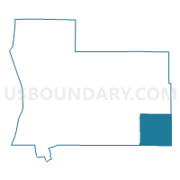
Outline

Summary
| Unique Area Identifier | 595854 |
| Name | Voting District 0095064000002 |
| County | Antrim County |
| State | Michigan |
| Area (square miles) | 35.45 |
| Land Area (square miles) | 35.30 |
| Water Area (square miles) | 0.15 |
| % of Land Area | 99.57 |
| % of Water Area | 0.43 |
| Latitude of the Internal Point | 44.89506760 |
| Longtitude of the Internal Point | -84.89893330 |
Maps

Graphs
Select a template below for downloading or customizing gragh for Voting District 0095064000002, Antrim County, Michigan


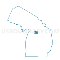
Neighbors
Neighoring Voting District (by Name) Neighboring Voting District on the Map
- Voting District 0091538000001, Antrim County, MI
- Voting District 0095064000001, Antrim County, MI
- Voting District 0097626000001, Antrim County, MI
- Voting District 0393048000001, Crawford County, MI
- Voting District 0790932000001, Kalkaska County, MI
- Voting District 0791700000001, Kalkaska County, MI
- Voting District 1373736000001, Otsego County, MI
Top 10 Neighboring County Subdivision (by Population) Neighboring County Subdivision on the Map
- Mancelona township, Antrim County, MI (4,400)
- Hayes township, Otsego County, MI (2,619)
- Coldsprings township, Kalkaska County, MI (1,464)
- Frederic township, Crawford County, MI (1,341)
- Star township, Antrim County, MI (926)
- Chestonia township, Antrim County, MI (511)
- Blue Lake township, Kalkaska County, MI (387)
Top 10 Neighboring Place (by Population) Neighboring Place on the Map
Top 10 Neighboring Unified School District (by Population) Neighboring Unified School District on the Map
- Gaylord Community Schools, MI (20,186)
- Kalkaska Public Schools, MI (12,425)
- Crawford AuSable Schools, MI (12,089)
- Mancelona Public Schools, MI (6,868)
- Alba Public Schools, MI (1,302)
Top 10 Neighboring State Legislative District Lower Chamber (by Population) Neighboring State Legislative District Lower Chamber on the Map
- State House District 104, MI (104,139)
- State House District 105, MI (95,524)
- State House District 106, MI (86,395)
Top 10 Neighboring State Legislative District Upper Chamber (by Population) Neighboring State Legislative District Upper Chamber on the Map
- State Senate District 35, MI (261,943)
- State Senate District 37, MI (258,370)
- State Senate District 36, MI (254,090)
Top 10 Neighboring 111th Congressional District (by Population) Neighboring 111th Congressional District on the Map
Top 10 Neighboring Census Tract (by Population) Neighboring Census Tract on the Map
- Census Tract 9607, Antrim County, MI (5,000)
- Census Tract 9506, Otsego County, MI (4,694)
- Census Tract 9601, Crawford County, MI (2,118)
- Census Tract 9506.01, Kalkaska County, MI (2,039)